Mapping & Modelling – Additional Worksheet
This optional worksheet covers extra material for you to reflect on the previous lecture material. If you have previously completed this material (e.g. during class time), you can scroll to the bottom of the page and press “Finished” to move on to the next step.
Your answers for this review will be saved for future access in the My Learning Dashboard. You can always submit the answers that you have so far and then continue again later if you are unable to finish the worksheet in one attempt.
Please take the time to think about your answers and apply any knowledge that you have learnt from the previous lecture. Remember to take notes of anything you are unsure of as there will be time in the next tutorial to review and ask any questions you may have.
Quiz Resources
The following cameras are similar to ones that could be used for an aerial survey:
- Camera A:
- Focal length: 16mm
- Sensor width: 23.5mm
- Sensor height: 15.6mm
- Image width: 6000px
- Image height: 4000px
- Camera B:
- Focal length: 35mm
- Sensor width: 23.5mm
- Sensor height: 15.6mm
- Image width: 6000px
- Image height: 4000px
- Camera C:
- Focal length: 24mm
- Sensor width: 43.2mm
- Sensor height: 32.4mm
- Image width: 8000px
- Image height: 6000px
Quiz Summary
0 of 9 Questions completed
Questions:
Information
You have already completed the quiz before. Hence you can not start it again.
Quiz is loading…
You must sign in or sign up to start the quiz.
You must first complete the following:
Results
Results
0 of 9 Questions answered correctly
Your time:
Time has elapsed
You have reached 0 of 0 point(s), (0)
Earned Point(s): 0 of 0, (0)
0 Essay(s) Pending (Possible Point(s): 0)
Categories
- Not categorized 0%
- 1
- 2
- 3
- 4
- 5
- 6
- 7
- 8
- 9
- Current
- Review
- Answered
- Correct
- Incorrect
-
Question 1 of 9
1. Question
What raw data could each of the following sensors be used to collect?
Sort elements
- Visible imagery
- Visible and non-visible imagery
- Full-spectrum imagery
- Low density terrain map
- High density terrain map
-
RGB Camera
-
Multispectral Camera
-
Hyperspectral Camera
-
RADAR Range Sensor
-
LIDAR Range Sensor
CorrectIncorrect -
Question 2 of 9
2. Question
How could the raw data for the following sensors be analysed to obtain additional information?
- Visible imagery
- Multispectral imagery
-
This response will be awarded full points automatically, but it can be reviewed and adjusted after submission.
Grading can be reviewed and adjusted.Grading can be reviewed and adjusted. -
Question 3 of 9
3. Question
Match the following terms:
Sort elements
- The physical size on the ground that each pixel in the image represents
- The speed that the aircraft is travelling relative to the ground
- The percentage amount of each captured image that will be the same as a previous image in the direction of travel
- The percentage amount of each captured image that will be the same as a previous image between each lane of a survey
-
Ground Resolution
-
Groundspeed
-
Overlap
-
Sidelap
CorrectIncorrect -
Question 4 of 9
4. Question
Considering the cameras listed in the Quiz Resources, what is the field of view for width and height (rounded up nearest degree) of each camera?
-
- Camera A:
- FoV width:
- FoV height:
- Camera B:
- FoV width:
- FoV height:
- Camera C:
- FoV width:
- FoV height:
- Camera A:
CorrectIncorrect -
-
Question 5 of 9
5. Question
Considering the cameras listed in the Quiz Resources, what is the ground resolution for each camera in “cm/px” (rounded to the nearest millimeter – first decimal place) if the aircraft is flying at 400ft?
- Note: “1 m/px” is “100 cm/px”
- Note: 1m = 3.28084ft
-
- Camera A: cm/px
- Camera B: cm/px
- Camera C: cm/px
CorrectIncorrect -
Question 6 of 9
6. Question
Which camera has the best ground resolution (e. would produce the most detailed images) if the aircraft is flying at 400ft?
CorrectIncorrect -
Question 7 of 9
7. Question
Is the ground resolution the same for each camera in the height and width directions of the image?
CorrectIncorrect -
Question 8 of 9
8. Question
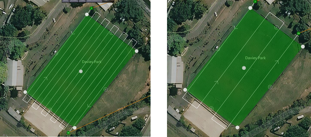
What is the most likely difference in survey settings the following patterns if both surveys were performed at the same altitude with the same cameras?
 CorrectIncorrect
 -
Question 9 of 9
9. Question
What would be the impact on a survey if the amount of overlap was increased?
CorrectIncorrect